Tampilkan postingan dengan label prescribed fire. Tampilkan semua postingan

Minggu, 08 Februari 2015

Crater the bay to restore it?

Carolina Bay wetland (1998);
the egg shaped, dark mass near the center of the image

Carolina Bays are enigmatic, isolated wetlands scattered across parts of the Atlantic Coastal Plain; enigmatic due, in part, to their characteristic northwest-southeast orientation, and ovoid shape, not to mention speculation as to their origin.

Whatever their ontogeny, most have been destroyed by ditching, draining, and other land-uses.  Many appear only as faint impressions on aerial images.


One reasonably intact example of a Carolina Bay is the object of our conservation & restoration efforts in Sampson Co, NC (shown on the image above). This bay persisted amidst a maze of logging roads and uplands managed intensively for timber production, unlike an adjacent example which was repeatedly logged and shows few remnants of its original wetland character. I have no explanation why this particular bay was spared. However, remnant vegetation persists, displaying characteristics of "cypress savanna".

Cypress Savanna (Sampson Co, NC)
with open canopy, multi-aged, scattered Pond Cypress (Taxodium ascendens),
Loblolly pines are also evident, inc; browned & dying trees in the background


The dominant trees throughout the wetland would likely have been Pond Cypress (Taxodium ascendens). Like the image above, there would have been a relatively open canopy, with few Loblolly pines (Pinus taeda), above a dense, herbaceous dominated ground layer. However, most of the bay is now closed canopied and dominated by Loblolly which invaded the wetland due to a combination of periodic droughts and very infrequent fire. 


Pond Cypress (left), loblolly pine (right)

Pines grow alongside cypress (see left), sometimes capitalizing on what appear to be raised mounds created by the Cypress. Because Cypress is both slower growing and more shade intolerant than loblolly, the predictable result is that pines will eventually replace the cypress.  They also absorb and transpire more water, drawing down the water table and further increasing their competitive advantage. 


Therefore, a primary restoration issue is removal of the pines. 


Given the sensitivity of the site, conventional logging was not an option, and felling individual trees was deemed too labor intensive. After extensive consideration and experimentation, we decided to bring fire back to the bay and implemented a prescribed burn in the middle of November.  


Loblolly pine overtopping pond cypress
Fire weather forecasting called for northeast winds @ 9 mph, 55 degrees, 44% humidity. Keetch-Byram drought index (KBDI) was high (over 500), and fuel moisture across all size classes was less than 20%. The fire carried well across the entire site, as expected.  Flame lengths stayed generally low although there was significant variation as measured by scorch heights afterwards. Active fire burned out quickly and was easily contained.  Dry fuel conditions allowed fire to smolder pockets of surface organic buildup consisting mainly of intertwined pine roots.  


Post Fire Conditions in Carolina Bay after November fire
Top: small pocket burned several inches deeper than surrounding, 
Middle: Red Maple roots exposed, heavily injured & toppled
Bottom: consistent surface organic reduction, some root exposure 

As a result, a number of trees throughout the bay succumbed. A few, like the Red Maple (Acer rubrum) shown above fell over and died immediately, while most trees either survived or died more slowly. The following chart displays the survival of the three most common trees, Loblolly Pine ("Pinus"), Cypress ("Taxodium"), and Maple ("Acer") across 5 diameter size ranges.  For a given species the colored lines within each size class show the number of stems before fire ("Pre") and the number surviving after ("Post"). 
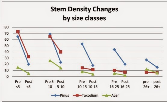

These data show relatively heavy stem losses of Pines (blue lines) across all size classes, while mortality of Cypress (red lines) was concentrated in the two smaller size classes. Taken together, this shows an overall shift away from the strongly pine-dominated vegetation of the Carolina Bay before fire to an equal mixture of pine & cypress after fire.  The lone fire was not sufficient to restore cypress savanna but it produced significant progress.

Growing season conditions following November fire;
Pond Cypress tree stands amidst several dead loblolly pines,
and above a living red maple


Minggu, 16 November 2014

Large-flowered Milkweed (Asclepias connivens)


Large-flowered Milkweed is one of the more distinctive milkweeds of the southeastern states, due to the unusually large, deeply cupped, individual flowers, that may reach nearly an inch across.

Individual flower (corona) of Asclepias connivens, displaying the "connivent" hood
Phylogentically, A. connivens is intermixed with African Milkweed species in clades developed by Fishbein (1996), providing some suggestion that our North American species may be derived from Africa; perhaps this implies this is also one of our more ancient species?


Large-flowered milkweed is a relatively narrow southeastern coastal plain endemic, ranging from extreme southeastern SC through coastal GA, into extreme southern AL, and across most of Florida, In the northern Florida panhandle, Asclepias connivens can be found in poorly drained, silty soil habitats that have been called wet flatwoods or prairies (Carr 2007); these sites have sparse tree canopies and well developed herbaceous layers.  The images included here are from two regularly burned sites taken on the same date. Plants at the most recently burned site were somewhat delayed in flowering compared to the site burned earlier in the season.

A. connivens coming into bloom in
standing water, recently burned savanna
(July 04, 2014)
A. connivens flowering in dense sward of grasses and herbs
under sparse canopy of longleaf pine
(July 04, 2014)

One of the sites could also be called a "wet savanna".  It had a sparse tree canopy of longleaf pine and a few Pond Cypress (Taxodium ascendans), including the two tallest stems shown in the midground below.  Some naturally occurring slash pine (Pinus elliotii) were present (seeding in from the adjacent forested wetland), but most of the smaller stems were killed by the last prescribed fire. In addition to numerous stems of Large-flowered Milkweed other notable species included Toothache Grass (Ctenium aromaticum), Parrot Pitcher Plant (Sarracenia psittacina), Pale Grass Pink (Calopogon pallidus), and Tracy's Sundew (Drosera tracyi)
Awesome wet savanna on St. Marks National Wildlife Refuge
Thanks to Jeff Glitzenstein for getting me there!


References:

Carr, S.C. 2007. Floristic and Environmental Variation of Pyrogenic Pinelands in the Southeastern Coastal Plain: Description, Classification, and Restoration. PhD Dissertation.

Fishbein, M.  1996. Phylogenetic Relationships of North American Asclepias and the Role of Pollinators in the Evolution of the Milkweed Inflorescence.  PhD Dissertation.

Jumat, 07 November 2014

Green Silky Scale


Green Silky Scale (Anthaenantia villosa) is a southeastern coastal plain endemic grass species, ranging from eastern Texas to Florida and northward into NC.
A. villosa upright habit and dense, flowering panicle
Note charred longleaf bole and open wiregrass dominated habitat
Image date: Nov 06, 2012

In our area I have observed it only in recently burned longleaf-wiregrass habitats in the inner coastal plain and sandhills regions. Within these generally dry, deep sandy soil sites, the grass occurs in gentle depressions (sometimes called "bean dips") or gentle, almost imperceptibly subtle slopes which are slightly moister than the surrounding uplands.

It occurs in dense swards of grasses where it can be easily overlooked unless flowering. Like a number of other species in these habitats, it may only flower (or at least most profusely) the growing season immediately after burning and may increase as a result. Kush et al. 2000 (in Alabama longleaf pine) documented much greater frequency for this species in biennially burned stands as compared to unburned stands with the greatest frequencies in summer and winter burn units.


Green Silky Scale (foreground), amidst dense wiregrass (Aristida stricta)
Sampson Co., NC (October 20,2011)


Silky Scale clumps turning color in Fall
Nov 06, 2014


Silky scale develops small rhizomatously spreading clumps which appear to expand slowly. Basal leaves are narrow, smooth, and tapering to a narrow tip. According to Grelen & Duvall (1966) leaves are nutritious and palatable forage.


Inflorescences form tight, narrow panicles on upright stems (maybe 3.5' tall) late in the growing season. Individual spikelets are densely pubescent and tightly packed along the upper 8 or so inches of the stem (See image right).


References:

Grelen and Duvall 1966, Common Plants of Longleaf Pine - Bluestem Range, Southern Forest Experiment Station Publication
Kush, J.S., R.S. Meldahl, and W.D. Boyer. 2000. Understory Plant Community Responseto Season of Burn in Natural Longleaf Pine Forests. Tall Timbers Fire Ecology Conference 21:33-39

Senin, 01 September 2014

Pine Barrens & Grasslands in New England; Part II

In a previous post I briefly discussed two examples of fire-maintained vegetation in southern New England (http://ncplantcon.blogspot.com/2014/08/pine-barrens-grasslands-in-new-england.html). Ecologically similar sites, often referred to as "pine barrens" or "pitch pine barrens" are scattered around the region.  I visited examples of this unique vegetation in Maine, New Hampshire, and Massachusetts in late summer (2014).

Pitch Pine barren near Waterboro, Maine
understory of lowbush blueberry, sweetfern, and bear oak


Some examples were enchanting forests; gnarly & twisted pines with charred boles, multiple age classes, and patchy ground cover openings. All sites occurred on "sandplains" or glacial outwash plains. These deep sandy soils supported two consistent species across all sites visited; Pitch pine (Pinus rigida) & Bear Oak (Quercus ilicifolia). Bear Oak was often heavily dominant as a tall shrub or dense midstory layer.
Pinus rigida bole displaying epicormic shoots
Bear Oak (Quercus ilicifolia)

Many areas I visited were thickly stocked with dense Pitch Pine, while others were open woodlands. Fire history could partially explain those density differences, with more frequently burned sites supporting the woodlands.

Much of the region around the Waterboro Barrens, was burned over in Maine's largest series of forest fires in 1947. Since that time (and prior to restoration work), a 93% decline in open canopy pitch pine has been documented (2).


In addition to the loss of open woodlands, Patterson (1) found that stands unburned since 1947 had developed highly volatile, well aerated fuels conducive to high intensity, fast moving fires.
Waterboro Barrens thinning;
dense forest (left) unthinned, open woodland (right) mechanically thinned. 
Not surprisingly, a proactive management strategy of mechanically thinning trees and brush around exterior boundaries of the site has been implemented. This strategy serves a dual purpose of minimizing fire behavior while "restoring" some of the open canopy woodlands that have been lost. This management strategy was also being implemented at a New Hampshire site I visited. Hand crews were actively cutting, clearing, and piling brush in much the same way we have done on fire reintroduction projects in North Carolina (one of which involved pitch pine). Examples shown here (below) were presumably thinned to achieve this open structure.

Waterboro, Maine
Concord, New Hampshire


Pitch Pine Woodlands:
(contrast both to image at top of page)


While appearing structurally similar, understory composition varied considerably; Concord (right) was much richer floristically and perhaps has a longer and/or more recent history of prescribed fire; prescribed burns began there in 2003 and ~ 20 acres or so have been burned in most years since then (3). Managers at Concord have a compelling reason to reintroduce fire. In addition to restoring a rare and declining natural community type, and reducing wildfire risk, their site is the only location in New Hampshire and the world's easternmost location known to support the Karner Blue Butterfly (4).
Karner Blue (Lycaeides melissa samuelis), Concord, NH
Thanks to Harry LeGrand for ID confirmation!
This federally endangered species (also found in the midwestern US, and mentioned in an earlier blog regarding the connection with Sundial Lupine) has been reintroduced to the site, along with Lupines by biologists in New Hampshire.  One relatively small portion of the site was exceptional for its grassy character (see image below). I observed a number of plants there, but in no other "barrens", including Big Bluestem, DogBane, New Jersey Tea, Ground Cherry, and others.
Grassy open Pitch Pine Barren@Concord, New Hampshire


Karner Blue (?) perched on Dogbane (Apocynum cannabinum)@ Concord, New Hampshire

It will be interesting to see what management activities, especially prescribed fires, are conducted across these barrens and the results they achieve. Reducing dangerous fuel loads while restoring more natural structure seems like a logical way forward (see below), but the real proof comes with fire.

Brush piles from hand clearing around large Pitch Pine @ Concord, NH


References:
(1) http://www.umass.edu/nebarrensfuels/publications/pdfs/waterboro_pot_fire_bx.pdf
(2) http://www.umass.edu/nebarrensfuels/ne_barrens/waterboro_kennebunk_hollis/waterboro.html
(3) http://www.wildlife.state.nh.us/Wildlife/Nongame/projects/karner_project.html
(4) http://www.fws.gov/midwest/endangered/insects/kbb/pdf/kbb5YrReviewSept2012.pdf

Jumat, 29 Agustus 2014

Pine Barrens & Grasslands in New England? Part 1

Leaving North Carolina for a casual visit to New England presents a bit of cultural and ecological shock. Its not just the accents but the vegetation!  While the southeastern US is known for some of the nations most fire-prone vegetation, New England's seems the polar opposite; dense, dark, forests heavy in Eastern Hemlock and White Pine, not the kind of places associated with frequent fire. While the majority of North Carolina may have experienced fires several times a decade (1) some authors have estimated fire return intervals in New England forests as infrequently as 230 to - 5,200 years (2)! Sort of boring stuff for a "normal" fire ecologist "down south".
Sandplain Grassland in southern Maine
with Northern Blazing Star


At least that's what I thought before I read the following prior to a recent visit to New England;
"It's a prairie, just like those out west," said Keith Fletcher, the Conservancy's Southern Maine Program Manager. "It has been maintained by (burning) for 5,000 years" (2).
Seriously,  I had to see that!


As the picture to the right illustrates, I was actually able to find a "prairie" in Maine. At least it was an open, mostly tree-less, herbaceous dominated site, on what appeared to be deep sandy soils. Experts at the Maine Natural Areas Program would likely call it a "Sandplain Grassland"(4).  I was lucky to be there just as the Northern Blazing Star (Liatris scariosa) was coming into bloom.  This plant is considered "Threatened" in Maine.  Flowering stems were beginning to poke up throughout the grassland, which seemed to be dominated by Poverty Oat Grass (Danthonia spicata).  The site was quite large and I was excited to explore, but the fact that the interior roads were closed for the season, coupled with the impatience of my travel partner to see the ocean (evidenced by some realistic looking tears) the visit was cut a bit short.


After a brief interlude at the coast, I was able (allowed?) to visit another jewel of southern Maine, the Wells Barren. My directions initially led me astray and caused me to nearly miss the site completely. Luckily that didn't happen because this place is great!

After an inauspicious start through "regular ole Maine Woods", the place opened up into an impressive "barren".


Unlike the "Prairie" or "sandplain grassland" at the previous site, the vegetation here was absolutely dominated by low-bush blueberry (Vaccinium angustifolium), often with an emergent layer of Pin Cherry (Prunus pensylvanica).

Fire Cherry over dense low-bush blueberry;
note Pitch Pines in background

Perhaps a better name for the Prunus is "fire cherry" in reference to its uncanny ability to recolonize burned areas. This appears to be the case at Wells Barren which is under fire management by The Nature Conservancy. There were a number of large Pitch Pine (Pinus rigida) around the perimeter but almost none in the interior where fire was presumably too frequent, or past land-uses had removed them.


Grassy, "sandplain-like" patch 
~ 10 meters in extent

Small openings stood out at a distance due to the tawny coloration of the Poverty Oat Grass, and the lack of Vacciniums or other shrubs. In one or two of these I noticed a few stems of Northern Blazing Star. These small areas looked like mini-sandplain grasslands. Not sure why these persisted or existed as islands in a sea of shrubs.  I could envision more frequent fire transitioning the whole site into a more grassy and less shrubby condition (perhaps explaining the first site?), but why these small islands in a matrix of blueberry with the same fire history?

Single Danthonia spicata clump
notice perimeter ring separation


One idea emerged after spotting a single grass clump (see image, lower right). This Poverty Oat Grass clump seemed to be surrounded by a small buffer separating it from the surrounding shrubs. It made me think of "allelopathy, a phenomenon where one species produces biochemicals that inhibits growth of others. A later bit of research turned up some evidence that, at least one Danthonia sp. is believed to exhibit alleloapthy (5).


Other than the extreme openness, or at least lack of well developed tree cover, the most notable aspect of the site was the density of Low bush blueberry (Vaccinium angustifolium). The image below gives some hint at this.


This site is a great reminder that fire has been used for many generations, and probably by native Americans, to enhance blueberry production.  Vaccinium angustifolium spreads primarily vegetatively, and this spread is encouraged by fire. It is well known in many regions that more vigourous blueberry growth often appears after fires.  It has been documented that heated or burned rhizomes produce more shoots (6).  At a site like this, it doesn't take long to pick your fill (See below) which may be reason enough to support more prescribed burning!

Next time we visit the Wells Barren we'll take a bucket


References:
(1) Frost, C. Presettlement Fire Frequency Regimes of the UNited States: A First Approximation..
(2) Fahey & Reiners.  1981.  Fire in the Forests of Maine and New Hampshire. Bulletin of the Torrey Botanical Club 108.
(3) http://www.seacoastonline.com/apps/pbcs.dll/article?AID=/20071115/NEWS/711150369/-1/NEWS14&sfad=1
(4) http://www.maine.gov/dacf/mnap/features/communities/littlebluestem.htm
(5) Slater, P.D., T.M. Cregan and P.D. Cregan. Allelopathic Effects of Danthona Richardsonii and Phalaris aquatica on Trifolium subterraneum. Australian Weeds Conference Proceedings.
(6) (Flinn, Marguerite A.; Pringle, Joan K. 1983. Heat tolerance of rhizomes of several understory species. Canadian Journal of Botany. 61: 452-457).


Minggu, 24 Agustus 2014

Prairie Flora in North Carolina - All Hands on Dock (Silphium terebinthinaceum)

Prairie Dock (Silphium terebinthinaceum), a.k.a Prairie Rosinweed, is among the most conspicuous herbaceous perennials of tallgrass prairies of the midwestern United States (1).  The same is true for certain remnant, prairie-like habitats in parts of the NC Piedmont as well. Part of its conspicuousness, no doubt, comes from the distinctive & large basal leaves that may reach 12" in length (see image below).


Flowering stalks bolt upwards in late July & early August, topped by ball-like buds. Stalks may reach 6-10 feet in height before opening into bright yellow flowers around mid-August.


Silphium terebinthinaceum basal leaves in Durham Co, NC

The epithet, "terebinthinaceum" translates to "with turpentine" a reference to the presence of rosins which give many species in the genus their common name. I assume the rosin content would be toxic or inhibitory to grazing animals, but rumor has it that the "rosin" was once chewed by pioneers and that the plant is actually favored by some grazing animals. Curtis (2) apparently observed a "virgin prairie" when it was first put to use as a livestock pasture. He indicated that the horses and cattle sought out prairie docks and compass plants "like hidden candy at a child's birthday party."  There are suggestions that bison also feed upon Prairie Dock, but I have found no definitive references to this, possibly because their ranges no longer overlap.

Prairie dock develops a significant taproot (see image at Reference # 3), unlike Silphium astericus with which it commonly co-occurs on many Piedmont, North Carolina sites. Dhillion & Friese (4) found that Silphium terebinthinaceum had high levels of mychorrhizal activity (a symbiotic association between the roots and specialized fungi that often confer advantages to the plant in the form of drought resistance, nutrient uptake, etc.).

Very little seems to be known about seed dispersal or pollination, but there are strong suggestions that both are extremely distance limited. Coupled with habitat fragmentation, the result is extreme isolation between remaining populations.

A review of the S. terebinthinaceum range map (see also #5) indicates that North Carolina populations are the easternmost in the nation, significantly disjunct from the heart of the main population centers in Illinois and Missouri (2). What is it doing here in the Piedmont of North Carolina?


The NC Natural Heritage Program records Prairie Dock occurrences in Cabarrus, Davie, Durham, Granville, Mecklenburg, Stanly, Union, & Wake counties. Populations in Durham & Granville occur on rich clayey soils apparently weathered from diabase rocks, often with other species with prairie affinities. Until such sites are managed to maintain, or recreate, open conditions Prairie Dock appears to decline and persist only on road edges and powerlines.
Prairie Dock rosettes persisting along roadway in Durham (2006);
lack of mowing allowed dense saplings to encroach & suppress
 most individuals present
Same site as previous; mowed during growing season (May 2007)
Same site as previous; note numerous Prairie Dock rosettes (Sept 2007)
For long-term habitat improvement & maintenance prescribed fire is the most desirable technique and we have applied it with spectacular results at several Piedmont sites.  In most cases, our spring fires move relatively rapidly, exposing individual plants to direct heating for a short amount of time.  Hahn & Orock (6) found that Prairie Dock seeds are able to maintain viability even after 15 minutes of exposure to 150 degree C!


I concur with Schramm (6) "one would think that by now, fire would be universally accepted and vigorously applied in all restoration and management efforts, but fire is being used to conservatively." In addition, he says, "most remnants ... currently need regular burning to regain their original quality", a statement I also agree with in the Piedmont where prairie associated flora remains.


A grove of Prairie Dock flowering (Aug 2014) at site in Durham Co, NC
(same site as shown in preceding sequence)


REFERENCES:
(1) Gleason H.A. and Cronquist A. 1991. Manual of Vascular Plants of Northeastern United States and
Adjacent Canada. 2nd ed. The New York Botanical Garden, The Bronx, New York.
(2) Curtis, J.T. 1959. The Vegetation of Wisconsin. UW Press.
(3) Robertson, K. R. 2007 image.  see - http://www.inhs.uiuc.edu/~kenr/prairiephotos/silptere.root1.jpg
(4) Dhillion & Friese; http://images.library.wisc.edu/EcoNatRes/EFacs/NAPC/NAPC13/reference/econatres.napc13.sdhillion.pdf)
(5) http://plants.usda.gov/core/profile?symbol=SITE
(6) Hahn P.G. & Orock, J.L. 2014. Effects of Temperature on Seed Viabaility of Six Ozark Glade Herb Species and Eastern Red Cedar (Juniperus virginiana). American MIdland Naturalist 171: 147-152
(7) Schramm, no date; http://images.library.wisc.edu/EcoNatRes/EFacs/NAPC/NAPC12/reference/econatres.napc12.pschramm2.pdf

Minggu, 27 Juli 2014

Restoring the Larkspur Savanna


Tall Larkspur (Delphinium exaltatum) approaches its southern range limit in North Carolina. Only a handful of sites have been documented and the species is considered endangered.  Of the 2 documented records in the Piedmont region, one is now extirpated (by the creation of a water line), and the second persists in a narrow slice of habitat between a paved road and a frequently disturbed water line.

Several years ago with the financial support of the NC Natural Heritage Trust Fund (now defunct), we were able to purchase a wooded tract adjoining the lone remaining Piedmont population.  The plan was to restore the densely forested tract hoping the Larkspur could re-occupy more natural habitat away from the constant threats associated with living on the roadside.


Dense patch of Eastern Red Cedar killed by
prescribed fire under large shortleaf pine

Since then, we have conducted 3 or 4 prescribed burns across the tract, combatted invasive species, and cleared some of the dense tree growth present.

The forest has scattered remnant trees with growth forms indicative of savanna growth. However, these were shrouded in dense growth of young Eastern Red Cedar (Juniperus virginiana) and little light reached the forest floor. Prescribed fires and selective tree removal have begun to produce desired results.

After several years, the upland edge of the site has begun to appear much more open.  In the following images a shortleaf pine and dogwood can be seen before and after preliminary restoration; more shortleaf pines become apparent deeper in the woods on the latter image.
   

Maintaining and expanding the developing "Larkspur Savanna" continues to demand resources. 
Restoration in progress at Larkspur Savanna, 2014 (above)
w/small pile of Eastern Red Cedar logs & brush piles
browned ground was dense Japanese Stilt Grass (Microstegium vimineum

Aerial views show the expanding opening.
Site in 2010, before hand-clearing
Site in 2013, after hand-clearing


Over the last several years we have been lucky to have several dedicated individuals carry the load of our restoration efforts at this site.

Earlier this year, Thomas Blaine has taken on thinning and brush-cutting to expand potential habitat. He shocked me, and perhaps himself, with discovery of the first Tall Larkspur plants outside of the original patch!

Not to be outdone, our local Preserve Stewards, Herb & Pat Amyx discovered a few more plants upslope of Thomas' just days later.  Taken together, these finds have expanded the extent of the Piedmont's lone Tall Larkspur population by more than 100 meters.

Popular Posts

Recent Posts

Categories

Unordered List

Text Widget

Pages

Diberdayakan oleh Blogger.